Cartographic Data in 3D
SpacEyes3D Builder allows you to visualize all your cartographic data in 3D. A perfect complement to your GIS software, SpacEyes3D Builder is an easy-to-use application that is simple to learn.
VISUALIZE AND ANALYZE YOUR SPACE
Viewing in 3D enables a new way of displaying – and understanding – your information.
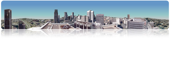
Present your projects in 3D
A superior tool for decision-making and collaboration, SpacEyes3D Builder allows you to add a new dimension to your work.
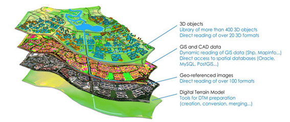
All standard formats are supported by SpacEyes3D Builder (only a subset is provided below):
- DTM: ASC, XYZ, GeoTiff, Bil
- Imagery: GeoTiff, JPEG2000, ECW,
- SIG Vectors: Shape, MapInfo, DXF
- Spatial Databases: MySQL, Oracle Spatial, PostGIS, SQL Server
- Remote imagery: OGC/WCS, OGC/WMS, ECWP
- Cloud hosted raster and vector files: browse and display files stored on AWS S3, Microsoft Azure Blob, Google cloud storage, AliBaba cloud OSS
- 3D : OBJ, 3DS, DXF, COLLADA, OSGB (paged or not)
Easy to integrate into an existing software environment
SpacEyes3D Builder is easy to learn and integrate with other systems:
- No specific 3D knowledge required
- Simple and easy-to-use interface
SIMULATE YOUR SETTLEMENT PROJECTS
Import complex 3D objects, preview your plans of phased development in a realistic environment.
Intuitive management
With an intuitive management of 3D layers, SpacEyes3D lets you visualize analyses created within 2D GIS systems :
- Immediate addition of new layers, including rasters, vectors and 3D objects
- Transparency, swipe feature, setting thresholds
- Choice of the display style for vector layers
- Hierarchical folders and layers structure
Advanced GIS features
SpacEyes3D includes many advanced GIS features :
- Advanced dynamic 3D representation of data such as overlays, extrusions, labels, symbols and hyperlinks
- Thematic classification
- Interactive consultation of the database attributes
- Filter and search functions
- SQL requests
- Interactive measurements in the 3D scene
Complete freedom of creation
Create your 3D models without constraints :
- Instant creation of the 3D scene via immediate integration of new DTMs and orthoimages
- Data preparation tools provided for DEM creation, assembly, reprojection, fusion, correction and optimization
COMMUNICATE IN 3D
Create interactive presentations integrating your own information directly in the 3D model : vector texts, images and, layouts.
Use thematic views features to create menus and associate to menu entries : points of views, overflights, scenarios, etc.
Create 3D models quickly
Immediately add objects in the 3D view of a scene
- Text tool, image or icon, arrow, overlay, 3D markers
- Import complex 3D models: 3DS, DXF, LWO, KML/KMZ, Collada
Distribute your creations
Distribute your presentations as movies or photos
- HD video files
- High-resolution perspective views
- 360° panoramas
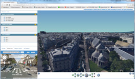
You can also distribute your data packed or create interactive terminals with the free SpacEyes3D Viewer.
You can also embed your 3D scenes into web page using SpacEyes3D Plugin and develop custom web or desktop applications using the API and the web framework.